Archive for June, 2010

Walking with Roberta Mock on 20 June 2010

June 23, 2010

Tamar Valley

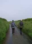
I am walking with Roberta. Roberta is the editor of the collection Walking, Writing and Performance Autobiographical Texts by Deirdre Heddon, Carl Lavery and Phil Smith. In the introduction to this she admits that “I am not the most obvious person to guide you into a book about performance practices related to walking. Nobody would describe me as a walker by inclination, experience, or temperament.” This, she proposes, is because she is from the suburbs of Detroit, where of course everyone drives.  (In fact, the link to Detroit is too neat, because the suburb of Detroit from which Roberta actually hails is in Windsor, Canada. Nevertheless, the atmosphere of the motor city travels.)  Today, though, I am making Roberta walk. She warns me in advance that she may grumble, bitch, moan…

But the day is made for walking. The sky is a deep, uninterrupted blue that you could fall into. We walk up the driveway of her converted barn, “Detroit House”, onto a farm track. It smells of countryside already – cows, grass, milking sheds. Roberta says that since moving out here she has begun to learn things about the country, without even realising it; like when it’s Pheasant season, or why farms are stocking mixed breeds of cows. The track leads past North Ward Farm, down to the Tamar River. We pass directly under the impressive Calstock Viaduct, built in 1908. The edge of the river is a remarkable place to stand as on this side, we are in Devon, whilst on the other side, spitting distance really, is Cornwall (Calstock). A Cornish flag (black, white cross), marks the boundary change (and underneath it, a Pirate’s flag flaps). There’s a small pier here, for the ferry boat.

Having reached the river’s edge, we double back on ourselves, walking along a “path” that’s so overgrown with tall grasses it’s almost disappeared. The grasses are dried out, brittle. Yachts and rowing boats bob on the river. The current is strong, apparently, so swimming across to the other side is not recommended. Journeying this way, we pass in front of Roberta’s house, seeing it from another perspective. It really is an idyll. Above it, the outline of the lush, managed woods, within which nestles Cotehele Manor House.

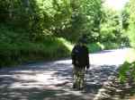
Following the bend of the river, we come to a wooded lane, an almost luminous green corridor that offers temporary respite from the sun. Even in this short distance, our environment has changed repeatedly, from dirt track, to long grasses, to wood. Stepping out from the cover of the trees, the river view opens up again. This is as far as Roberta usually comes. We have walked her local walk and are now walking into the less familiar.

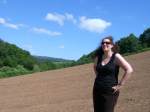
Passing behind a large house beside the river – Mary’s house – we arrive at a field that looks recently tilled. The uniformity of the brown is startling after the textures of deep greens. We need to cut across this field to reach a gate on the other side. The field is dry, dusty and very steep, but as we climb it, the view gets better. Roberta’s husband Paul has sketched a useful diagram of the route we’re meant to take (knowing that Roberta isn’t too familiar with the way). A gate is drawn at the edge of the field, and finding a gate, we immediately go through it.  Before long, we are confronted with a veritable field of nettles. Very tall nettles. Almost as tall as Roberta, which is quite something. The nettles sting through our trousers and soon we have to walk with our arms above our heads. But as the nettles are so tall, I realise this will soon offer me (a fair bit shorter than Roberta) no protection. Common sense also tells us that, having climbed up the hill, it makes no sense to immediately descend the same hill. We decide we’ve probably taken a wrong turn and retrace our steps.  The brambles scratch me and get tangled in Roberta’s curly hair.

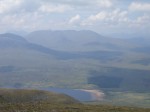
Returning to the field we notice that there’s another gate nearby, this one clearly marked with a public footpath arrow. The path leads over a little bridge, and then onto another dirt track, beside which a huge field of maize is growing. It’s nearly noon, and the sun is high. The track is steep. This, on top of the steep hill just climbed, makes Roberta a little reticent (well, she had warned me). But we take our time, stop, rest, drink water, admire the spectacular view of the Tamar River below. (I learn that stopping in her tracks, and sitting wherever she happens to be, is Roberta’s own particular way of coping. She’s fine after a few moments of “time out” from walking.) The track is lined with bunches of tall stems of fox gloves. As it gets more dusty underfoot, we feel like we could be in a Western (as long as we don’t look at the lush land all around). Just after agreeing this, we spot a trailer that’s actually called, appropriately, “West”. And at the top of the hill, a working farm. We rest under the shade of a tree, like weary travellers, slugging greedily from the water bottle, drinking in the view below. Roberta, true to character and upbringing, admires the mix of the bucolic and the rusting farm debris. At the base of the tree, a snapped windscreen wiper lies abandoned.

The farm track leads us finally to the tarmac road. I’ve worried that the sun will reflect off it, making it feel even hotter, but in fact as soon as we step onto the road, there’s a cool, welcome breeze. It’s mostly flat or downhill too, which perks Roberta up. Sweet scented honeysuckles bloom in the wild hedges. This road leads us back to “Detroit House”, the end of our circular walk. As we arrive, a pair of buzzards circle in the field beside the barn, and a heron flies over. Roberta has travelled far from the suburbs of Detroit. Though she may not picture herself as much of a walker (can you ever take Detroit out of the girl?), she has in fact taken me on a magical walk, and we have mostly walked side by side, basking in the beauty of this landscape.

Walking with Andy Heddon on 19 June 2010

June 22, 2010


Drifting Around Exeter

I am walking with my younger brother, Andy. We both moved to Exeter in 1998. I left in 2005 but Andy stayed. Andy frames his walk as being about randomness and chance, things just happening, without forward planning. It is, he proposes, something of a reflection on his life. There’s a less personal history to this sort of walking too perhaps, in the perambulations of the nineteenth-century flâneurs, an undirected strolling that nevertheless allows for attention to the surrounding environment.

Our walk, though, begins with clear intentions and a definite plan, as Andy wants to head to the Double Locks pub. We start at Cathedral Green. Sponsored teddy bears with parachutes are being thrown from the top of a fire engine’s ladder, raising funds for charity. At Fore Street, we pass by the print shop where Andy has worked for the past 9 years. A large design that he’s made covers an entire pane of glass – blue sky, green grass. There’s a van parked outside The Mint pub, a British Bulldog standing proudly erect atop its roof. The black door at 142 Fore Street hides a warren of houses, one of which Andy used to live in. A little further down, on the other side, 126 Fore Street, where he lives now – a top floor flat with stunning views. A little further down again, and the flat where he lived only a few months ago. It is clear that Andy has a fondness for Fore Street.

From here, we turn left onto West Street, passing a book shop called Drystones (a knowing nod, Andy reckons, to that chain street bookshop). There are three bookshops in this one area: a book exchange; an independent bookshop; and the Book Cycle – where you leave a donation for any book you want. Opposite the Book Cycle is the House that Moved – a Tudor building that was literally moved from one location in the city and rebuilt here.

On the other side of the busy dual carriageway, we gaze down onto a moss-planted roof and old water mill wheels. England flags hang from windows, telling of World Cup aspirations (though hopes are being rapidly dashed). We’re soon onto Exeter Quay, crossing the River Exe in Butt’s Ferry, a hand operated cable ferry. Opposite, is Bar Venezia, where Andy used to work. New buildings have appeared since I was last here, and more old warehouses have been brought into commission, filled with antiques and junk. At the side of the Exe, we spy some romantic graffiti: ‘Wait 4 me my love, your sweetheart’.

This is a path I used to saunter frequently. The sun is warm and bright and it smells of summer. Bees buzz busily in the tall grasses and wild flowers . The river carries canoeists, paddling alone or in pairs. At the Double Locks, Andy stands in the entrance, holding what he calls his ‘catalogue pose’ for the camera.

The Double Locks is where my students had a graduation gathering. It’s where I had my own wee leaving do too. At the canal side tables, Andy treats me to a Farm’s cider. It must be an acquired taste because it tastes like I imagine horse hoof oil to taste, or cow’s piss. Despite my best efforts, I can’t drink it. We catch the 2pm ferry back along the river. Andy knows the ferryman, Rich. In fact, Andy knows a lot of people in Exeter. Exeter is the place where he’s made deep roots.

Back on terra firma, we walk up the remarkable Stepcote Hill, a mediaeval cobble-stoned, steep stepped street. This takes us too near to Andy’s flat for him to resist popping home for a cup of tea (as if all that sitting, drinking cider and taking a ferry back up the river was thirsty work!) Then we walk back to Cathedral Green, to the open-air shopping mall erected since my departure. The new and the old rub up alongside each other – the old city wall next to the glass walls of high street shops; Egypt Lane etched in glass, which leads to Wagamama’s noodle restaurant. The Blue Boy statue has survived all the development though, still standing sentry.

Leaving the sterile newness of the shopping mall, we head into the markedly different ambience of Sidwell Street. The abandoned Debenhams now seems powerfully iconic. From Sidwell Street we make our way along Well Street, past the forlorn St. James Football park and then to Rosewood Terrace, a quiet, narrow street  packed with tiny two-up, two-downs. Number 3 is the house that Andy and I shared when we first moved here. Andy, with a broken collar bone and pelvis, slept downstairs.

Back along Sidwell Street – the Primary School has been demolished and rebuilt and a rather creepy collection of wicker people dance in the playground. Close by, a new Mosque is nearly completed. Then down Queen’s Crescent, onto Longbrook Street. The removal firm/storage unit has disappeared, replaced by Longbrook Salon and Isca Loft apartments. But 60 Howell Road looks exactly as it did 5 years ago – the door and window ledges the same blue I painted them, only a little more faded. This is the first house I owned, a single room on each of its three floors. I loved the sanctuary it provided in the centre of the city.

Andy’s at a bit of a loss as to where to go next, so we drift back on to Exeter High Street, packed with weekend shoppers. A visit to Sainsbury’s is, I am assured, still part of the walk. It also  handily functions as an opportunity for Andy to buy the ingredients for his dinner. I suspect this last stop is much more purposeful than the flâneurs would have liked. All day, though, I have been drifting through the seven years I spent here, my legs falling into old patterns and carrying me – almost without thinking – to former homes and significant places.

Walking with Peter Thomson on 16 June 2010

June 20, 2010
Kilcreggan – Rosneath – Kilcreggan
 
I am walking with my friend. mentor and former colleague (from the University of Exeter), Peter Thomson. Our walk, we imagine, retraces a walk taken in the summer of 1890 by Peter’ s  Great Grandfather, John Thomson. Peter has in his possession a letter written by John Thomson to his son Hugh, dated 18 August 1890. Telling of an enjoyable day trip (lasting 8 ½ hours), the letter’s narrative provides the plot for our walk. We read that John Thomson, his wife Mary, and Aunt Tina took a ferry from Row point, near Helensburgh, over to Rosneath. From here they walked to Kilcreggan, where they boarded the “Jeannie Deans” and sailed to Craigendoran, “thence to Helensburgh by train”.

Our journey (like theirs), begins in Glasgow, taking the train out to Helensburgh. There’s no boat anymore from Row point, but we can take a tiny sea bus from Helensburgh to Kilcreggan. Standing at the boat’s stern we watch the spectacular panorama emerge, one mountain becoming five. As we land at Kilcreggan I wonder if the huge, barnacle covered wooden pier is the same one that John Thomson would have seen more than a century ago.

Stepping onto it, our walk proper begins. Peter sets the pace, I follow. We are accompanied not only by the spirits of John Thomson and his walking companions, but by his walking stick too, which Peter has brought along. The silver inscription at its top reveals that he was given this dark wooden stick, topped with a smoothed bone handle, on the 2 June 1869 – a gift from the Sabbath Class that he ran. John had lost his leg in an accident in 1868. The walking stick is tiny, too small for Peter to use as a walking aid, but he swings it expertly nevertheless. When it touches the ground, I imagine it reconnecting with its history. It has been here before, even if we have not.

The road out of Kilcreggan is immediately steep but pays back with a stunning view out across the water. The road is also the main road (B833). Unlike in 1890, it is a busy thoroughfare and we are somewhat risking our lives by walking it. There are no pavements for almost the entire way (which makes us laugh when we encounter a sign that warns us that there is no footpath for 900 yards – as if a footpath had been a steady feature to this point). Drivers seem somewhat startled to encounter us on this road.

In spite of the traffic, the landscape is beautiful. John Thomson writes enthusiastically of the path being one of “continuous and varied beauty”, with “thickset verdant woods which threw an agreeable shadow in a hot sunshiny day”. The woods remain thickset and verdant, and as our own day is hot and sunshiny too the shifting shadows are welcome ones. The long grass verges are coloured with bursts of pink Campion and pastel hues of Comfrey. A shimmering buttercup field seems set alight. There’s Dog Rose, and swathes of Rhododendrons draw a purple line under the forest plantation high up on the hillside. We even spot some bamboo, presumably escaped from a garden.

The hill descends to the curved shore of Gare Loch, offering a view down its length, with the Alps of Arrochar in the far distance (described dramatically by John Thomson as “dark and solemn, altogether a union of the sublime and the beautiful”). The foreshore is bustling with birds – a Heron standing at the water’s edge, a group of mallards, a flock of crows, and a pair of swans with a single downy-feathered cygnet. Next to them, a nest – made of equal parts rubbish, grass and twigs – with four large, shiny eggs. We finally reach the village of Rosneath, at the centre of which lies the Clachan – a row of old houses (probably here in 1890), along with a small Co-Op (definitely not here in 1890). Ferry Road seems a good bet, and from here on to Gare Road, off which is a dirt-trodden path leading directly to the pebbly shore of Gare Loch.

It is sweltering hot. We sit, with picnic and cool Cider, looking out onto the lapping water, to the shores on the far side, the hills in the distance. Just beside us, the remains of what might be an old pier. Perhaps this is where John, Mary and Tina alighted. Perhaps they too sat here, enjoying the sun, taking in the view, before heading off towards Kilcreggan.

It is time for us to head off too, to walk in the direction they walked, from Rosneath to Kilcreggan. The tide has come in. The swan is back on her nest. The trees still look verdant. The sun still shines.  It’s so hot, that the tar sticks to the soles of my shoes. The cows and sheep are dozing in the field. But the going is a little easier this way, as it’s more downhill than up. Peter swings his inherited stick, energetically, enthusiastically (he walks more like a 10 year old than a man in his 70s).

Back at Kilcreggan, we cool down with a pint. John Thomson would likely disapprove (and, in this respect, Peter Thomson is definitely not one of John Thomson’s bairns). Here, we must part ways with John, Mary and Aunt Tina, for the “Jeannie Deans” from Kilcreggan to Craigendoran is no longer (though we did pass the old pier at Craigendoran on the way to Helensburgh). The sea bus transports us instead to Gourock, thence to Glasgow by train.

I have enjoyed the company of Peter’s ancestors immensely, the ways they have framed this land for me as I attempted to walk in their footsteps. But I have enjoyed Peter’s company even more, his keen aliveness, and the tangible sense that with each step taken there is a gladness  to be just here, experiencing this place and rewalking this walk for the first time. Tomorrow, I will continue to walk with Peter’s spring in my step.

Walking with Gordon Heddon on 9 June 2010

June 14, 2010

Alloa

I am walking with my dad. We’re heading off to the place of his childhood, in fact the town where he lived till he left home – Alloa. It seems remarkable to me – bewildering even – that I have never been here before.

The train station at Alloa only opened in 2008. Its previous one had closed in 1968 (the year before I was born). My dad tells me that when he first alighted at the new station he was completely disorientated. Nothing was how he remembered it. He then realised this was because the station had physically moved a few hundred metres from where it used to be. Along with the new station, there’s a massive new Asda which sits on the previous site of the Alloa Brewery. This used to be a vibrant industrial town: 8 or so breweries (ale as well as lager – including, latterly, Skol – a name I remember); a handful of mines; a woollen mill; a busy river port (River Forth);  and a glassworks. The glassworks is all that now remains, but even when my dad was a boy the town was in a slump.

Walking down Primrose Street we come to the grand, civic ‘Public Baths and Gymnasium’. The ‘baths’ part of it, where my dad learned to swim, is no longer operational. The pool has been covered over with a large blue gymnastics floor, the colour of which at least allows me to imagine what it might have looked like filled with water. Light streams through the glass pitched roof.

On High Street dad provides a roll-call of the previous lives of shops – this one used to be owned by his mum’s friend; that used to be the Co-Op; that empty one used to sell bikes…  The Bingo hall used to be the cinema, where he would go and see films on Saturday mornings.

At Candleriggs he points out Cram’s Bar, where, as a young man, his tipple would be rum and blackcurrant. Down onto Greenside Street, and the impressive Kilncraigs. Built in 1904, this is all that remains of the wool-spinning mill belonging to John Paton Son & Co, a company founded in 1814 which then became Patons & Baldwins. My granddad Ken worked here. Kilncraigs is now a business centre, its old architecture melded with a modern glass and steel frontage.

Further along Greenside Street are the remains of the 17th Century Parish Church’s tower, like a Tollbooth, with a glorious golden cockerel weather vane gleaming in the sun. There’s also a striking Art Deco building that my dad remembers being the Gas showrooms (and which is now the Careers building). At Lime Street – where the kids used to run around barefoot – is the church on the corner that he attended as a boy.  The streets of Alloa tell something of its previous history: Mill Street, Coalgate, Ludgate…

The grand houses on the edge of the town speak of an affluent past too (many are probably divided into flats now). The old post office has become a home (To Let). The garden centre, owned by the Colvilles, has become a row of new apartments, called, appropriately, Colville Gardens. The site of my dad’s primary school is now a block of dreary brown flats; the roundabout and main roads are additions to the landscape too. Even the war memorial has been moved here from somewhere else.

We walk on to Claremont, on the corner of which there used to be a sweetie shop, popular when rations were lifted. The properties at this end of Claremont are huge – at the window of one stands a fully armoured knight. As the street unfurls the houses become more modest and dad points out former homes of former school friends. And then we arrive – ‘Braeside’, 56 Claremont Street – dad’s old home. Built in the mid-1930s under his granny’s instructions (an unusual occurence, surely), it has 3 bedrooms, with the living room and kitchen looking out onto a spectacular view of the Ochil hills. In the garden stand two large trees planted by dad – a cherry and a holly. (Portents of the profession he would go on to choose –  the Forestry Commission). Dad is certain that the house’s front door is the same as when he lived here.

Retracing his dog-walking route (a Shetland Collie) we soon pass the former site of Alloa Academy, glimpsing the flat roofed structure of his old school. In front of this, there’s a newer building, erected in 1989. Remarkably, this too is now empty and awaiting demolition as Alloa Academy has moved. Dad still remembers his wonderful school motto – Look Aboot Ye (not a hint of Latin in sight.)

Beyond the old school, the extensive wooded parkland has forfeited a large chunk to the spread of modern bungalows. We make our way into the ‘Pleasure Grounds’, above Stirling Road. They used to be well maintained, and the flashes of views that we catch between the thick bushes are spectacular – right down to the river and beyond to the fields. I can understand why this was a favourite place. Where once there were benches, though, now there are only empty spaces or the occasional bench-skeletons. Finally, a single intact bench offers us a perfect spot for our picnic. Fittingly, we sit under a canopy of tall Corsican Pines, with glorious blooms of rhododendrons to our left. My dad last sat here when he was seventeen – 50 years ago. Having received his Higher examination results, this is where he came to think about his future, the options opening up, the choices to be made. I ask him what he’d say to his younger self: ‘I’d say. you didn’t do at all badly, not bad at all.’ This is a good answer.

As I’m sitting, a cone from a tree falls directly onto me. I put it in my pocket. We wind our way back to the new station, seeking in vain any signs of the old one.  Tomorrow morning, the pine cone, resting on my kitchen table, will open itself up and gently cast its seeds.

Walking with Greg Giesekam and Lalitha Rajan on 5 June 2010

June 6, 2010

Beinn An Dothaidh

I am walking with Greg and Lalitha. I have known Greg since I was an undergraduate student (he was also my PhD  supervisor). I have known Lalitha, now Greg’s wife, from when we were postgraduates together.

 My 10th walk is the first one to take me up a Munro – Beinn An Dothaidh (Hill of the Scorching). Sitting on the edge of Rannoch Moor, it rises to 3293 feet. Greg walked this hill some 15 years ago, passing through and then looking down upon thick fog and cloud (which eventually evaporated). Today, it’s hot and sunny and I coat myself in Factor 50.

We begin our walk at the Bridge of Orchy train station and the route is well marked by a path that leads up the coire. At the start, a cheerful greeting made out of white stones laid on the ground welcomes us: ‘Hallo’, with a stone arrow helpfully pointing north (up the hill). The going is a steady ascent for the first section, not overly strenuous. It eases my legs and lungs into the concept of hill walking, warming them up, getting them into a rhythm. (Though I walk a lot, I do not walk up a lot of hills.) Looking back down the route just covered, even from here the view is something to behold, as the landscape opens up.

The ground is so dry in places it almost resembles sand. There are scatterings of wild mountain flowers, summery yellow and striking purple. The path gleams as the sun hits the surfaces of some of stones that seem almost metallic. Singular, huge boulders, presumably abandoned in the glacier melt, stud the hill side. Stopping for a rest and a snack, we enjoy the scene below, looking out across to Loch Tulle, my binoculars bringing the impressive Black Mount Lodge close.

Though there’s a sort of accepted etiquette to walking (saying hello to the people passing in the other direction), hill walking magnifies it for the passing is often an overtaking, as faster walkers stride ahead. But then at some point, they will stop for a rest, and you will in turn pass by them. And so this swapping of places will continue all the way up and down, forging a sort of camaraderie and temporary community of fellow walkers. Faces will become familiar, walking styles observable (look at the speed, look at the sure-footedness…)

As we walk further into the coire, a burn to our left cascades enticingly. Oh, to dip these hot feet into that cool water. At one point we cross it, and splash our faces, a momentary reprieve. During their ‘courtship’ Greg used to recite poetry to Lalitha when they walked in the hills. I’m impressed by that romantic gesture, though not surprised that Greg is a Romantic (he admits to bringing books of poetry with him on his walks; Walt Whitman was a favourite).

Soon, the Coire an Dothaidh becomes much steeper, and zig zagging, with high steps that make my thighs strain and my pulse race. The scree surface is pretty precarious in places, and even with the thankful loan of a walking pole, I find myself scrambling a bit. Finally, puffed, we’re at the top of the coire, the bealach, which is marked by a cairn. We have our lunch here, flanked on both sides (Beinn An Dothaidh on our left, and Beinn Dorain on our right), with a stunning view down to Loch Lyon. Though Beinn Dorain means Mountain of the Otter, Lalitha spots a huge hare, belting down Dothaidh and disappearing out of view up Dorain. Its winter coat still looks pretty intact. Patches of snow remain visible on the hill side.

This is not the summit of our walk though, just a temporary resting place. From here, the visible path continues fairly steeply up Dothaidh before petering out as the land turns boggy. The bogs provide perfect conditions for strikingly colourful mosses. One moss is almost black, as if charred. We head towards the ridge, on the way encountering a solid slab of snow, still more than a foot deep. (One can only imagine how deep it must have been in the winter.) It is creating its own wee stream of water, as the sun beats down on it. We dig into it, taking handfuls of mountain ice cream (totally low fat). The snow tastes startlingly cool, refreshing us for the last haul up the side of the hill. The grass here is dried out and yellowing (which explains the name of this mountain). 

Heading towards what Greg believes is the summit, I’m concerned as I can’t see a cairn marking it – could it be another trick of perspective? But reaching it, I find that I am, indeed, on top of the mountain. And on top the world. Standing on the plateau, we have a 360 degree vista. Though it’s a bit hazy, the view is breathtaking. In front of me, Rannoch Moor opens out, and mountain range after mountain range unfolds, all the way to Ben Nevis. It’s a view to soak up, to dwell on, to marvel at. This is why people climb hills. From up here, the hard effort makes full sense. ‘You can see why summits are known as the armchairs of the Gods’, says Greg.

It’s taken us four hours to get up here but it will take only two to walk back down. My ankles will begin to feel the pressure, Lalitha’s knees will throb, but we will be spurred on by the thought of a cool drink at the Orchy Hotel. Tomorrow, my legs will ache, a pleasant reminder of the heights they have carried me, of the priceless gift that walking (and friends) can deliver.

Walking with Mike Pearson and Heike Roms on 29 May 2010

June 3, 2010

Pembrokeshire Coastal Path

I am walking with Mike and Heike, friends made in the field of ‘performance’. Our paths have crossed for quite a few years now, though usually in the midst of conferences about history and live art, or performance and landscape.  I have also peviously walked as if I was Mike, retracing a performance of a guided tour he did around the village of his childhood (“Bubbling Tom”, Hibaldstow). I relish the prospect of walking with Mike this time.

Mike and Heike have booked us in to The Clock House, a lovely Guest House in Marloes (complete with a three course dinner that includes an offer of locally caught lobster). The aim is to reach their favourite place for walking: Skomer Island, which lies just off the Pembrokeshire Coast. It’s something of a bird watcher’s paradise (and Mike is something of a bird watcher. Though I own some binoculars, I’m not so great on identification.) The weather forecast predicted heavy rain and indeed, though I went to sleep in balmy, summery conditions, I am woken by the sound of a torrent. Rain is ok though – the wee boat to Skomer can cope with rain. It’s wind that’s the problem.

During breakfast the news is delivered that Kenny, the boat man, is unable to take day visitors over to Skomer today as the wind is picking up and we might get stranded there. Not getting to Skomer is something of a regular occurrence, and probably a large part of the island’s appeal. So I won’t get to experience Mike and Heike’s favourite walk after all; but curiously that seems appropriate. I appreciate the gesture of them wanting to share it with me. However, it remains their favourite walk, a walk they do together, and its being ‘off-limits’ to me seems almost poetic. The previous night, studying an aerial photograph, Mike gave me a virtual tour so I can, at least, imagine where the puffins nest.

By the time we’ve finished breakfast, the rain has stopped and we head out to walk their second favourite walk, for the most part following the glorious Pembrokeshire Coastal Path. A handy walking map, produced by The Clock House proprietors, Phil & Sue, guides us easily to the start of the walk, just behind the Guest House. Almost immediately, we are plunged into a verdant green canopy, and then onto a narrow, quiet county road, flanked on both sides by wild hedges, home to Whitethroats. Passing by a Youth Hostel, its roof made of lime (to prevent it from being blown off in the regularly high winds) we make our way to Marloes Mere, a marshland complete with handy bird hide. A brief stop here, spotting Little Grebe with even littler Grebe chicks, and the much maligned (common) Mallard.

Then back on to the road and heading West towards the coast. The sound of the sea, even from this distance, provides a constant background rumble. As we get nearer, we can see the waves breaking ferociously on the land’s edges. The steep path leads us down to Marloes Sands, a spectacular landscape whose geology feels almost prehistoric. Huge sheets of layered rock arranged at sharp angles provide a scale which makes me feel small. Heike takes a picture of us all, setting her new ‘retro’ camera on self-timer. (It’s the sort of camera that prompts her to come over all ‘Audrey Hepburn’.) Returning to the path, I manage to spot a bird; it’s hovering, so it doesn’t look like a gull. In fact, it turns out to be a Peregrine Falcon (having a bird watcher as a fellow walker is very useful). I feel proud of myself for spotting something (even if I could not have named it). It’s fitting that a Peregrine hovers above our peregrinations. A ‘resident’ breed to these parts, though, is the Chough. I’ve never seen Chough before, but put on the alert, I spot one, and then we see a fraternity ducking and diving beside the cliff, red legs and beaks separating them from crows. I can’t resist saying that I’m chuffed (corny though I know that is).

Continuing along the coastal path, and through a kissing gate (where a sign tells us that the sheep have learned how to open it), we see a Kestral, hovering, then swooping. It’s sunny, warm, but very windy. Reaching Deer Park, we head down to the inlet, Martin’s Haven, to use the public loos. Remarkably, these are the havens for nesting swallows too and they fly about our heads, quite untroubled by our presence. A welcome packed lunch is eaten, sitting in the bay (where the boat to Skomer is moored), and then back up to Deer Park (a deer wall was built in the eighteenth century, though deer were never actually introduced. Now, it’s home to wild ponies). Tramping through the vibrantly yellow gorse, we spot another breed of the area, the Stonechat. And on our way to the exposed headland, Wooltack Point, we see a single seal, and a single Gannet. At Wooltack Point, braving the strong headwinds,  we look across to Skomer Island, our shadow walk.

From here, we’re on the last leg of the walk, the start of which is a steep climb up a bank (like climbing a ladder, says Mike). The carpet of wildflowers on this walk has been memorable: bright yellow gorse, pink campion, fox gloves, pink clovers, large daisies, seas of bluebells: purples, whites, blues, pinks, yellows… The flora provides the foundations for fragile gossamer shelters too, spun by caterpillars biding their time till they transform into butterflies.

Walking high above Musselwick Sands, where the tide is out and we can see body boarders paddling in the sea, a bit of sand graffiti proclaims proudly ‘I love Dad’. A wooden sign informs us that we’re nearing the end (1 mile to Marloe), and it’s probably just as well, as our feet and legs are beginning to feel the 9 miles we’ve walked.

Back at The Clock House, I feel windswept and sun kissed and bank holiday blessed. All of me is utterly refreshed. The sensations of this land have impressed themselves upon me.

Pembrokeshire Coastal Path (and a bit extra)